In addition to the 50,205 acres of subtidal area, the Reserve includes 1,955 acres of state-owned land. State park locations are accessible to the public and offer a variety of recreational opportunities. Natural area preserves and coastal reserves do not widely support active recreation but can easily be enjoyed via kayak or canoe from several nearby public launch sites.
Looking for a hiking trail in a Reserve site? Explore the CT Trail Finder.
Looking to launch your boat or kayak, sit by the water, or bird watch within the Reserve? Explore the CT Coastal Access Guide.
Reserve sites include:
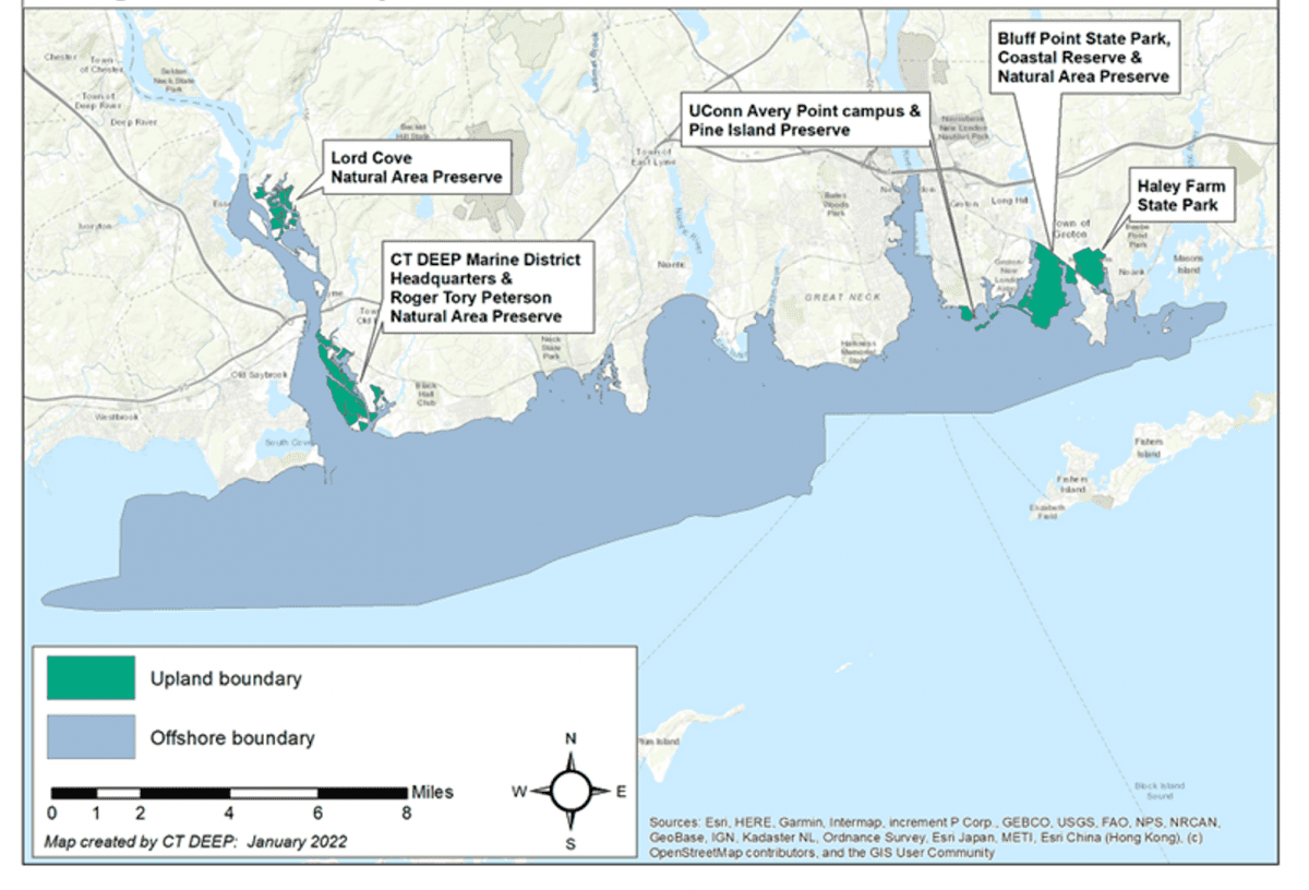
The Lord Cove Natural Area Preservation (formerly Lord Cove Wildlife Management Area) encompasses about 200 acres of brackish reed marsh and floodplain forest. In the high-marsh zone, the narrow–leaved cattail, can reach an average height of 5 feet and form monospecific colonies. It’s also adjacent to intertidal flats and submerged aquatic vegetation beds.
The Connecticut Department of Energy and Environmental Protection’s (DEEP) Marine Headquarters provide opportunities to support NERR functions and activities. This site includes DEEP’s Fisheries and Boating divisions, a boat launch for small vessels, and a public access boardwalk along the Great Island marshes.
The University of Connecticut (UConn) Avery Point campus is the headquarters for the Reserve and houses the primary administrative, research, and education offices. The Avery Point facilities, located on 72 acres of land and bordered on three sides by water, contain classrooms, laboratories, and offices. UConn also owns Pine Island in Groton, a State Archaeological Preserve with rich history.
The Roger Tory Peterson Natural Area Preservation (formerly Great Island Wildlife Management Area) consists of an extensive system of salt and brackish meadow marshes. It is located at the mouth of the Connecticut River, the only principal river in the northeastern United States without a major port or urban area there. This has preserved the rural character of the regional landscape and helped maintain the River’s extraordinary array of natural and relatively undisturbed biotic communities. Although much of this site is protected, visitors can enjoy the Roger Tory Peterson Estuary Center.
Bluff Point State Park, Coastal Reserve, and Natural Area Preserve a variety of habitats – coastal woodlands, beach and dune grasslands, coastal ponds, coastal bluffs, tidal wetlands, intertidal mud flats, and offshore eelgrass beds. Over 200 bird species have been seen here, including many uncommon to Connecticut, but that use the area during migration seasons. To learn more, visit the Bluff Point State Park website.
Haley Farm State Park is a mosaic of upland and wetland vegetation types. Algae and intertidal plants are found on the shores of Palmer Cove. The swampy areas have red maple and tulip trees, but the uplands include cherry, hickory and shrubs. As a former working farm dating to the Colonial era, remnants of numerous stone walls dot the landscape. Haley Farm is one of the more accessible State parks, providing handicap access to parking and trails. To learn more, visit the Haley Farm State Park website.